Andrew's Map Catalog

Monday, April 18, 2011

DLG


http://pubs.usgs.gov/of/2003/of03-471/domier/index.html

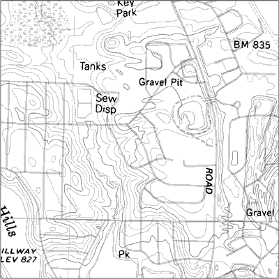
A digital line graph displays digital vector data in the form of lines (arcs), points, and areas (polygons).  DLGs are able to display multiple forms of cartographic data such as PLSS, political boundaries, topography, roads, hydrography.  The image above is a DLG of a region of Illinois.
Posted by AndrewHo at 8:34 AM
Email ThisBlogThis!Share to XShare to FacebookShare to Pinterest

No comments:

Post a Comment

Newer Post Older Post Home
Subscribe to: Post Comments (Atom)

Blog Archive

  • ▼  2011 (51)
    • ▼  April (51)
      • Triangulated Irregular Network
      • Isopleth
      • Nominal Choropleth
      • Unstandardized Choropleth Map
      • Cartographic Animations
      • Statistical Map
      • Continuously variable proportional circle map
      • Box Plot
      • Parallel Coordinate Graph
      • Lorenz Curve
      • Univariate Choropleth
      • Bivariate Choropleth
      • Classed Choropleth
      • Correlation Matrix
      • Similarity Matrix
      • Stem and Leaf Plot
      • Histogram
      • Windrose
      • Population Profiles
      • Index Value Plot
      • Bilateral Graph
      • DOQQ
      • DLG
      • Star Plot
      • Climograph
      • PLSS
      • Cadastral Map
      • Propaganda Map
      • Triangular Plot
      • Scatterplot
      • Cartogram
      • Flow Map
      • Isoline
      • DRG
      • DEM
      • Doppler radar
      • Infrared Aerial Photo
      • Black & White Aerial Photo
      • LIDAR
      • Proportional Circle
      • Dot Distribution
      • Thematic
      • Choropleth
      • Isopach
      • Isohyet
      • Isotach
      • Hypsometric Map
      • Topographic Map
      • Planimetric Map
      • Isobars
      • Mental Map

About Me

My photo
AndrewHo
View my complete profile
Travel theme. Powered by Blogger.